


The insightful articles, inspiring narrations and analytical perspectives presented by the Editorial Team, establish an alluring connect with the reader. My compliments and best wishes to SP Guide Publications.

"Over the past 60 years, the growth of SP Guide Publications has mirrored the rising stature of Indian Navy. Its well-researched and informative magazines on Defence and Aerospace sector have served to shape an educated opinion of our military personnel, policy makers and the public alike. I wish SP's Publication team continued success, fair winds and following seas in all future endeavour!"

Since, its inception in 1964, SP Guide Publications has consistently demonstrated commitment to high-quality journalism in the aerospace and defence sectors, earning a well-deserved reputation as Asia's largest media house in this domain. I wish SP Guide Publications continued success in its pursuit of excellence.
Maritime surveillance requirements are demanding specific capabilities and performance such as mission endurance, flight profiles, mission equipment and human factors. Until recently, such missions were performed exclusively by aircraft – some dedicated for the maritime surveillance mission, with others using off-the-shelf transport planes modified for the mission. These missions typically demand coverage of very wide areas, monitoring extensive maritime traffic, as well as deployment in unexpected conditions, in response to emergencies or on search and rescue missions. Therefore, the need for efficient development of a maritime situational picture is critical, enabling the deployment of the few available aerial assets to cover only those areas or targets of significance.
The introduction of unmanned aircraft platforms is changing this paradigm, removing the limitations that have restricted manned missions, while introducing new capabilities that significantly enhance operational flexibility and efficiency of maritime control. This capability is specifically important in recent years, as countries are required to cover growing maritime areas claimed by the exclusive economic zones (EEZ) that span up to 200 nautical miles from their coastline or farthest island. In the case of India, for example, such area covers a huge expanse of the Indian Ocean, bordering Indonesia in the east to Somalia in the west. A country cannot cover such vast space from its coastal radar stations, nor can it commit manned patrol flights to cover the entire area.
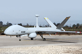
At Aero India 2013 in Bengaluru Elbit Systems introduced its newest and largest unmanned aircraft system (UAS) – Hermes 900 in a new configuration adapted for maritime mission. This UAS can carry payloads of up to 350 kg. In the maritime configuration the payload suite includes maritime surveillance radar, AIS, an electro-optical multi-sensor payload and electronic surveillance systems. It has the endurance to cover vast ocean areas, redundant line-of-sight and satellite communications links and radio relay, enabling the operator to ‘talk through’ to vessels at sea. The aerodynamic efficiency of the Hermes 900 enables frequent changes in flight profiles, enabling visual identification of vessels at sea in addition to the ISAR capability provided by the radar. Satellite communication enables it to fly to mission areas at extended ranges as far as 1000 nautical miles from shore.
A unique capability supported by Elbit Systems command and control systems is the ability to control two UAS simultaneously from a single ground control station, using the two redundant data-links. This has a significant effect on the assets, manpower and operating cost, as well as in improving the efficient utilisation of UAS that can now cover more area or run a denser surveillance over a given area. The maritime command and control system employed at the ground control is optimised for the maritime mission, supporting specific mission planning applications such as maritime search, Search and Rescue, etc. The entire command and control is located in a single shelter, which can be operated on shore in a mobile shelter base or indoor configurations at sea or co-located in several locations.
Recognising the extraordinary challenge of monitoring the Indian EEZ and vast shoreline, Elbit Systems has teamed with Windward Ltd. in order to tackle this challenge from a different point of view and offer a unique solution to the Indian authorities.
A unique solution presented at Aero India for the first time globally is the combination of our UAS with MarInt – a maritime analytics system – as the search light for UAS operations. The use of unmanned assets with MarInt can empower Navy, coast guard, customs, environmental monitoring and other authorities in better enforcing laws and regulations in their territorial waters and EEZ, providing them with powerful means to take legal action and recover lost assets, thus deterring offenders from repeating such violations. Operating 24/7, MarInt reveals areas of suspicious activities and pinpoints anomalous vessels. This enables tasking of unmanned assets such as UAS to patrol the designated areas, identify and track the suspicious vessels, significantly optimising aerial patrol and increasing mission effectiveness while reducing cost.