


The insightful articles, inspiring narrations and analytical perspectives presented by the Editorial Team, establish an alluring connect with the reader. My compliments and best wishes to SP Guide Publications.

"Over the past 60 years, the growth of SP Guide Publications has mirrored the rising stature of Indian Navy. Its well-researched and informative magazines on Defence and Aerospace sector have served to shape an educated opinion of our military personnel, policy makers and the public alike. I wish SP's Publication team continued success, fair winds and following seas in all future endeavour!"

Since, its inception in 1964, SP Guide Publications has consistently demonstrated commitment to high-quality journalism in the aerospace and defence sectors, earning a well-deserved reputation as Asia's largest media house in this domain. I wish SP Guide Publications continued success in its pursuit of excellence.
A team of senseFly engineers marked a new milestone in surveying techniques’ history by demonstrating that mini-drone mapping technology is capable of producing a 20-cm resolution 3D model of the epic Matterhorn, known as “the most beautiful mountain” worldwide.
For the first time a team of engineers from senseFly was able to create a digital model of the Matterhorn with a 20-cm resolution in three dimensions.
The data was aquired during a total of 11 flights by several eBee mini-drones flying concurrently and collecting over 2,200 images within just a few hours. In cooperation with our partner Pix4D and through eBee’s image processing software Postflight Terra 3D-EB a highdefinition 3D point-cloud was created made of 300 million points and covering an area of over 2,800 hectares with an average resolution of 20 cm. 3D mission planning based on elevation data and multi-drone operation, two features recently released in senseFly’s ground control software eMotion 2, were instrumental in the success of this mission and the unprecedented quality of the dataset.
The project was realised in cooperation with Drone Adventures (planning and logistics), Pix4D (data post-processing) and Mapbox (online visualisation).
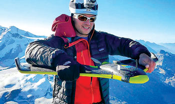
The small weight and transportability of these ultralight drones enabled the team to carry and launch them from three different remote location and altitudes, thus fullfill Swiss requirements of in-line-of-sight operations.
One drone was carried by Team 1 in a backpack up to the summit of the Matterhorn. The challenge was to test take-off behaviour at high altitude and in mountain typical turbulances. The ebee was launched at the summit of the Matterhorn (4,478 metres), climbing up to an maximum altitude of 4,707 metres, flying over the top of this epic mountain and mapping the west face.